Quick start
For a demonstration of how pydriosm works with OpenStreetMap (OSM) data, this part of the documentation provides a quick guide with some practical examples of using the package to download, parse and store the OSM data.
Note
All the data for this quick-start tutorial will be downloaded and saved to a directory named “tests” (which will be created if it does not exist) at the current working directory as you move from one code block to another.
The downloaded data and those being generated during the tutorial will all be deleted from the “tests” directory; a manual confirmation will be prompted at the end of the tutorial to determine whether the “tests” folder should remain.
Download data
The current release version of the package works mainly for the OSM data extracts that is available for free download from Geofabrik and BBBike download servers.
To start with, you could use the class GeofabrikDownloader (see also pydriosm.downloader) to get a sample from the free Geofabrik download server.
>>> from pydriosm.downloader import GeofabrikDownloader

>>> # Create an instance for downloading the Geofabrik data extracts
>>> geofabrik_downloader = GeofabrikDownloader()
To explore what data is available for download, you may check out a download catalogue by using the method .get_download_catalogue() :
>>> # A download catalogue for all subregions
>>> geofabrik_download_catalogue = geofabrik_downloader.get_download_catalogue()

>>> # Check the column names
>>> geofabrik_download_catalogue.columns.tolist()
['Subregion',
 'SubregionURL',
 '.osm.pbf',
 '.osm.pbf.Size',
 '.shp.zip',
 '.osm.bz2']

>>> geofabrik_download_catalogue.head()
      Subregion  ...                                           .osm.bz2
0       Algeria  ...  https://download.geofabrik.de/africa/algeria-l...
1        Angola  ...  https://download.geofabrik.de/africa/angola-la...
2         Benin  ...  https://download.geofabrik.de/africa/benin-lat...
3      Botswana  ...  https://download.geofabrik.de/africa/botswana-...
4  Burkina Faso  ...  https://download.geofabrik.de/africa/burkina-f...
[5 rows x 6 columns]
If you’d like to download say the protocolbuffer binary format (PBF) data of a specific geographic region, you need to specify the name of the region and file format (e.g. ".pbf"). For example, to download the PBF data of 'London' and save it to a local directory named "tests":
>>> subregion_name = 'London'  # case-insensitive
>>> osm_file_format = ".pbf"  # or ".osm.pbf"
>>> download_dir = "tests"  # a download directory

>>> # Download the OSM PBF data of London from Geofabrik
>>> geofabrik_downloader.download_osm_data(subregion_name, osm_file_format,
...                                        download_dir, verbose=True)
To download .osm.pbf data of the following geographic region(s):
    Greater London
? [No]|Yes: yes
Downloading "greater-london-latest.osm.pbf" to "tests\" ... Done.
Note
If the data file does not exist at the specific directory, you’ll be asked to confirm whether to proceed to download it, as a function parameter
confirmation_requiredisTrueby default. To skip the confirmation, you just need to set it to beFalse.If the
download_dirisNoneby default, the downloaded data file would be saved to a default data directory, which in this case should be"osm_geofabrik\Europe\Great Britain\England\".
Now you should be able to find the downloaded data file at “<current working directory>tests*”, and the filename is “*greater-london-latest.osm.pbf” by default.
To retrieve the default filename and the full path to the downloaded file, you could set the parameter ret_download_path to be True when executing the method:
>>> path_to_london_pbf = geofabrik_downloader.download_osm_data(
...     subregion_name, osm_file_format, download_dir, confirmation_required=False,
...     ret_download_path=True)

>>> import os

>>> # Default filename:
>>> london_pbf_filename = os.path.basename(path_to_london_pbf)
>>> print(f"Default filename: \"{london_pbf_filename}\"")
Default filename: "greater-london-latest.osm.pbf"

>>> # Relative file path:
>>> print(f"Current (relative) file path: \"{os.path.relpath(path_to_london_pbf)}\"")
Current (relative) file path: "tests\greater-london-latest.osm.pbf"
Alternatively, you could also make use of the method .get_default_path_to_osm_file() to get the default path to the data file (even when it does not exist):
>>> london_pbf_filename, default_path_to_london_pbf = \
...     geofabrik_downloader.get_default_path_to_osm_file(subregion_name, osm_file_format)

>>> print(f"Default filename: \"{london_pbf_filename}\"")
Default filename: "greater-london-latest.osm.pbf"

>>> path_to_london_pbf = os.path.join(download_dir, london_pbf_filename)
>>> print(f"Current (relative) file path: \"{os.path.relpath(path_to_london_pbf)}\"")
Current (relative) file path: "tests\greater-london-latest.osm.pbf"
In addition, you can also download data of multiple (sub)regions at one go. For example, to download PBF data of three different regions, including 'Rutland', 'West Yorkshire' and 'West Midlands' (where you can set confirmation_required=False to waive the requirement of confirmation to proceed to download the data):
>>> subregion_names = ['Rutland', 'West Yorkshire', 'West Midlands']

>>> paths_to_pbf = geofabrik_downloader.download_osm_data(
...     subregion_names, osm_file_format, download_dir, ret_download_path=True,
...     verbose=True)
To download .osm.pbf data of the following geographic region(s):
    Rutland
    West Yorkshire
    West Midlands
? [No]|Yes: yes
Downloading "rutland-latest.osm.pbf" to "tests\" ... Done.
Downloading "west-yorkshire-latest.osm.pbf" to "tests\" ... Done.
Downloading "west-midlands-latest.osm.pbf" to "tests\" ... Done.

>>> type(paths_to_pbf)
list

>>> for path_to_pbf in paths_to_pbf:
...     print(f"\"{os.path.relpath(path_to_pbf)}\"")
"tests\rutland-latest.osm.pbf"
"tests\west-yorkshire-latest.osm.pbf"
"tests\west-midlands-latest.osm.pbf"
Read/parse data
To read/parse any of the downloaded data files above, you could use the class GeofabrikReader (see also pydriosm.reader).
>>> # Create an instance for reading the downloaded Geofabrik data extracts
>>> from pydriosm.reader import GeofabrikReader

>>> geofabrik_reader = GeofabrikReader()
PBF data (.pbf / .osm.pbf)
To read the PBF data, you can use the method .read_osm_pbf(), whose parser depends largely on GDAL/OGR. Also check out the function parse_osm_pbf() for more details.
Now, let’s try to read the PBF data of Rutland:
>>> subregion_name = 'Rutland'
>>> data_dir = download_dir  # "tests"

>>> rutland_pbf_raw = geofabrik_reader.read_osm_pbf(subregion_name, data_dir)

>>> type(rutland_pbf_raw)
dict
rutland_pbf_raw is in dict type and has five keys: 'points', 'lines', 'multilinestrings', 'multipolygons' and 'other_relations', corresponding to the names of the five different layers of the PBF data.
Check out the ‘points’ layer:
>>> rutland_pbf_points = rutland_pbf_raw['points']

>>> rutland_pbf_points.head()
                                              points
0  {"type": "Feature", "geometry": {"type": "Poin...
1  {"type": "Feature", "geometry": {"type": "Poin...
2  {"type": "Feature", "geometry": {"type": "Poin...
3  {"type": "Feature", "geometry": {"type": "Poin...
4  {"type": "Feature", "geometry": {"type": "Poin...
Each row of rutland_pbf_points is textual GeoJSON data, which is a nested dictionary.
>>> import json

>>> rutland_pbf_points_0 = rutland_pbf_points['points'][0]
>>> type(rutland_pbf_points_0)
str

>>> # Decode the str-type data
>>> rutland_pbf_points_0_ = json.loads(rutland_pbf_points_0)
>>> type(rutland_pbf_points_0_)
dict

>>> list(rutland_pbf_points_0_.keys())
['type', 'geometry', 'properties', 'id']

>>> rutland_pbf_points_0_
{'type': 'Feature',
 'geometry': {'type': 'Point', 'coordinates': [-0.5134241, 52.6555853]},
 'properties': {'osm_id': '488432',
  'name': None,
  'barrier': None,
  'highway': None,
  'ref': None,
  'address': None,
  'is_in': None,
  'place': None,
  'man_made': None,
  'other_tags': '"odbl"=>"clean"'},
 'id': 488432}
The charts (Fig. 1 - Fig. 5) below illustrate the different geometry types and structures (i.e. all keys within the corresponding GeoJSON data) for each layer:

Fig. 1 Type of the geometry object and keys within the nested dictionary of 'points'.

Fig. 2 Type of the geometry object and keys within the nested dictionary of 'lines'.

Fig. 3 Type of the geometry object and keys within the nested dictionary of 'multilinestrings'.

Fig. 4 Type of the geometry object and keys within the nested dictionary of 'multipolygons'.

Fig. 5 Type of the geometry object and keys within the nested dictionary of 'other_relations'.
If you set parse_raw_feat (which defaults to False) to be True when reading the PBF data, you can also parse the GeoJSON record to obtain data of ‘visually’ (though not virtually) higher level of granularity:
>>> rutland_pbf_parsed = geofabrik_reader.read_osm_pbf(subregion_name, data_dir,
...                                                    parse_raw_feat=True,
...                                                    verbose=True)
Parsing "\tests\rutland-latest.osm.pbf" ... Done.

>>> # Data of the parsed 'points' layer
>>> rutland_pbf_parsed_points = rutland_pbf_parsed['points']

>>> rutland_pbf_parsed_points.head()
         id               coordinates  ... man_made                    other_tags
0    488432  [-0.5134241, 52.6555853]  ...     None               "odbl"=>"clean"
1    488658  [-0.5313354, 52.6737716]  ...     None                          None
2  13883868  [-0.7229332, 52.5889864]  ...     None                          None
3  14049101  [-0.7249816, 52.6748426]  ...     None  "traffic_calming"=>"cushion"
4  14558402  [-0.7266581, 52.6695058]  ...     None      "direction"=>"clockwise"
[5 rows x 12 columns]
Note
The data can be further transformed/parsed through two more parameters,
transform_geomandtransform_other_tags, both of which default toFalse.The method
.read_osm_pbf()may take dozens of minutes or longer to parse large-size PBF data file. If the size of a data file is greater than a specifiedchunk_size_limit(which defaults to50MB), the data will be parsed in a chunk-wise manner.If only the name of a geographic region is provided, e.g.
rutland_pbf = geofabrik_reader.read_osm_pbf(subregion_name='London'), the function will go to look for the data file at the default file path. Otherwise, you must specifydata_dirwhere the data file is located.If the data file does not exist at the default or a specified directory, the function will try to download it first. By default, a manual confirmation of downloading the data is required. To waive the requirement, set
download_confirmation_required=False.If
pickle_it=True, the parsed data will be saved as a Pickle file. The function will try to load the Pickle file next time when you run it, provided thatupdate=False(default); ifupdate=True, the function will try to download and parse the latest version of the data file.
Shapefiles (.shp.zip / .shp)
To read shapefile data, you can use the method .read_shp_zip(), which depends on pyshp (or optionally, GeoPandas, which is not required for the installation of PyDriosm).
For example, let’s try to read the ‘railways’ layer of the shapefile data of London:
>>> subregion_name = 'London'
>>> layer_name = 'railways'  # if layer_name=None (default), all layers will be included

>>> london_shp = geofabrik_reader.read_shp_zip(subregion_name, layer_names=layer_name,
...                                            feature_names=None, data_dir=data_dir,
...                                            verbose=True)
To download .shp.zip data of the following geographic region(s):
    Greater London
? [No]|Yes: yes
Downloading "greater-london-latest-free.shp.zip" to "tests\" ... Done.
Extracting the following layer(s):
    'railways'
from "tests\greater-london-latest-free.shp.zip" ...
to "tests\greater-london-latest-free-shp\"
Done.
london_shp is in dict type, with the default layer_name being its key.
>>> london_railways_shp = london_shp[layer_name]

>>> london_railways_shp.head()
   osm_id  code  ...                                        coordinates shape_type
0   30804  6101  ...  [(0.0048644, 51.6279262), (0.0061979, 51.62926...          3
1  101298  6103  ...  [(-0.2249632, 51.4935445), (-0.2250662, 51.494...          3
2  101486  6103  ...  [(-0.2055497, 51.5195429), (-0.2051377, 51.519...          3
3  101511  6101  ...  [(-0.2119027, 51.5241906), (-0.2108059, 51.523...          3
4  282898  6103  ...  [(-0.1862586, 51.6159083), (-0.1868721, 51.613...          3
[5 rows x 9 columns]
Note
The parameter
feature_namesis related to'fclass'inlondon_railways_shp. You can specify one feature name (or multiple feature names) to get a subset oflondon_railways_shp.Similar to the method
.read_osm_pbf(), if.read_shp_zip()could not find the target .shp file at the default or specified directory (i.e.data_dir), it will try to extract the .shp file from the .shp.zip file (or download the .shp.zip file first if it does not exist, in which case a confirmation to proceed is by default required asdownload_confirmation_required=True).If you’d like to delete the .shp files and/or the downloaded data file (ending with .shp.zip), set the parameters
rm_extracts=Trueand/orrm_shp_zip=True.
In addition, you can use the method .merge_subregion_layer_shp() to merge multiple shapefiles of different subregions over a specific layer.
For example, to merge the ‘railways’ layer of London and Kent:
>>> layer_name = 'railways'
>>> subregion_names = ['London', 'Kent']

>>> path_to_merged_shp = geofabrik_reader.merge_subregion_layer_shp(
...     subregion_names, layer_name, data_dir, verbose=True, ret_merged_shp_path=True)
"greater-london-latest-free.shp.zip" is already available at "tests\".
To download .shp.zip data of the following geographic region(s):
    Kent
? [No]|Yes: >? yes
Downloading "kent-latest-free.shp.zip" to "tests\" ... Done.
Extracting the following layer(s):
    'railways'
from "tests\greater-london-latest-free.shp.zip" ...
to "tests\greater-london-latest-free-shp\"
Done.
Extracting the following layer(s):
    'railways'
from "tests\kent-latest-free.shp.zip" ...
to "tests\kent-latest-free-shp\"
Done.
Merging the following shapefiles:
    "greater-london_gis_osm_railways_free_1.shp"
    "kent_gis_osm_railways_free_1.shp"
In progress ... Done.
Find the merged shapefile at "tests\greater-london_kent_railways\".

>>> # Relative path of the merged shapefile
>>> print(os.path.relpath(path_to_merged_shp))
tests\greater-london_kent_railways\greater-london_kent_railways.shp
For more details, also check out the functions: merge_shps() and merge_layer_shps().
Import and fetch data with a PostgreSQL server
In addition to downloading and reading OSM data, the package further provides a module pydriosm.ios for communicating with PostgreSQL server, that is, to import the OSM data into, and fetch it from, PostgreSQL databases.
To establish a connection with the server, you need to specify the username, password, host address of a PostgreSQL server and name of a database. For example:
>>> from pydriosm.ios import PostgresOSM

>>> host = 'localhost'
>>> port = 5432
>>> username = 'postgres'
>>> password = None  # You need to type it in manually if `None`
>>> database_name = 'osmdb_test'

>>> # Create an instance of a running PostgreSQL server
>>> osmdb_test = PostgresOSM(host, port, username, password, database_name)
Password (postgres@localhost:5432): ***
Connecting postgres:***@localhost:5432/osmdb_test ... Successfully.
The example is illustrated in Fig. 6:
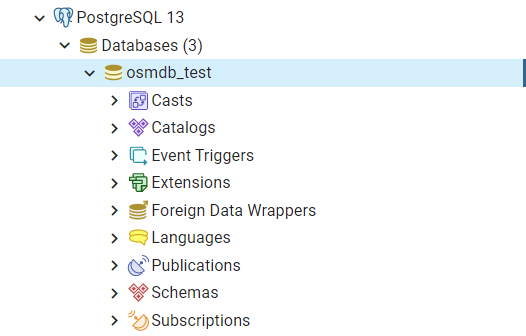
Fig. 6 An illustration of the database named ‘osmdb_test’.
Note
If you don’t specify a password (for creating the instance
osmdb_test) as the parameterpasswordisNoneby default, you’ll be asked to manually type in the password to the PostgreSQL server.The class
PostgresOSMhas incorporated all available classes from the modules:downloaderandreaderas properties. In the case of the above instance,osmdb_test.Downloaderis equivalent to the classGeofabrikDownloader, as the parameterdata_sourceis'Geofabrik'by default.To relate the instance
osmdb_testto ‘BBBike’ data, you could: 1) recreate an instance by settingdata_source='BBBike'; or 2) setosmdb_test.DataSourceto be'BBBike'
Import data into the database
To import any of the above OSM data to a database in the connected PostgreSQL server, you can use the method .import_osm_data() or .import_subregion_osm_pbf().
For example, let’s now try to import rutland_pbf_parsed that you have obtained from PBF data (.osm.pbf / .pbf):
>>> subregion_name = 'Rutland'

>>> osmdb_test.import_osm_data(rutland_pbf_parsed, table_name=subregion_name, verbose=True)
To import data into table "Rutland" at postgres:***@localhost:5432/osmdb_test
? [No]|Yes: yes
Importing the data ...
    "points" ... Done: <total of rows> features.
    "lines" ... Done: <total of rows> features.
    "multilinestrings" ... Done: <total of rows> features.
    "multipolygons" ... Done: <total of rows> features.
    "other_relations" ... Done: <total of rows> features.
Note
The parameter schema_names is None by default, meaning that you are going to import all the five layers of the PBF data into the database.
In the example above, five schemas, including ‘points’, ‘lines’, ‘multilinestrings’, ‘multipolygons’ and ‘other_relations’ are, if they do not exist, created in the database ‘osmdb_test’. Each of the schemas corresponds to a key (i.e. name of a layer) of rutland_pbf_parsed (as illustrated in Fig. 7); and the data of each layer is imported into a table named as ‘Rutland’ under the corresponding schema (as illustrated in Fig. 8).
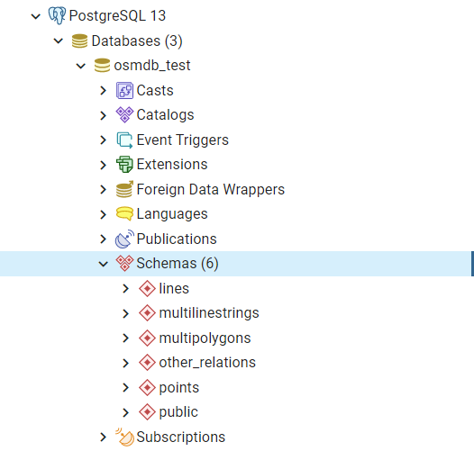
Fig. 7 An illustration of schemas for importing OSM PBF data into a PostgreSQL database.
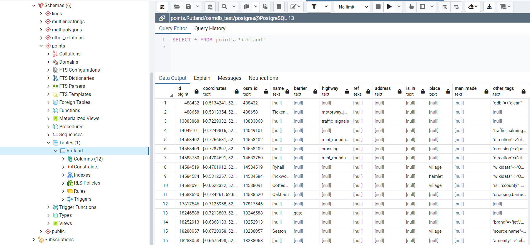
Fig. 8 An illustration of table name for storing the ‘points’ layer of the OSM PBF data of Rutland.
Fetch data from the database
To fetch all the imported PBF data of Rutland, you can use the method .fetch_osm_data():
>>> rutland_pbf_parsed_ = osmdb_test.fetch_osm_data(subregion_name, layer_names=None,
...                                                 decode_wkt=True)
You could find that rutland_pbf_parsed_ is an equivalent of rutland_pbf_parsed:
>>> check_equivalence = all(
...     rutland_pbf_parsed[lyr_name].equals(rutland_pbf_parsed_[lyr_name])
...     for lyr_name in rutland_pbf_parsed_.keys())

>>> print(f"`rutland_pbf_parsed_` equals `rutland_pbf_parsed`: {check_equivalence}")
`rutland_pbf_parsed_` equals `rutland_pbf_parsed`: True
Note
The parameter
layer_namesisNoneby default, meaning that you’re going to fetch data of all layers available from the database.The data stored in the database was parsed by the method
.read_osm_pbf()givenparse_raw_feat=True(see above). When it is being imported in the PostgreSQL server, the data type of the column ‘coordinates’ is converted from list to str. Therefore, in the above example of using the method.fetch_osm_data(), the parameterdecode_wktwas set toTrueto retrieve the same data.
Import/fetch specific layers of shapefile
Of course, you can also import/fetch data of only a specific layer or multiple layers (and in a customised order). For example, let’s firstly import the transport-related layers of Birmingham shapefile data.
Note
‘Birmingham’ is not listed on the free download catalogue of Geofabrik, but that of BBBike. You need to change the data source to ‘BBBike’ for the instance osmdb_test (see also the note above).
>>> osmdb_test.DataSource = 'BBBike'

>>> subregion_name = 'Birmingham'

>>> birmingham_shp = osmdb_test.Reader.read_shp_zip(subregion_name, data_dir=data_dir,
...                                                 verbose=True)
To download .shp.zip data of the following geographic region(s):
    Birmingham
? [No]|Yes: yes
Downloading "Birmingham.osm.shp.zip" to "tests\" ... Done.
Extracting "tests\Birmingham.osm.shp.zip" ...
to "tests\"
Done.
Parsing files at "tests\Birmingham-shp\shape\" ... Done.

>>> type(birmingham_shp)
dict

>>> # Check names of layers included in the data
>>> list(birmingham_shp.keys())
['buildings',
 'landuse',
 'natural',
 'places',
 'points',
 'railways',
 'roads',
 'waterways']

>>> # Import the data of 'railways', 'roads' and 'waterways'
>>> lyr_names = ['railways', 'roads', 'waterways']

>>> osmdb_test.import_osm_data(birmingham_shp, subregion_name, lyr_names, verbose=True)
To import data into table "Birmingham" at postgres:***@localhost:5432/osmdb_test
? [No]|Yes: yes
Importing the data ...
    "railways" ... Done: <total of rows> features.
    "roads" ... Done: <total of rows> features.
    "waterways" ... Done: <total of rows> features.
As illustrated in Fig. 9, three schemas: ‘railways’, ‘roads’ and ‘waterways’ are created in the ‘osmdb_test’ database for storing the data of the three shapefile layers of Birmingham.

Fig. 9 An illustration of the newly created schemas for the selected layers of Birmingham shapefile data.
To fetch only the ‘railways’ data of Birmingham:
>>> lyr_name = 'railways'

>>> birmingham_shp_ = osmdb_test.fetch_osm_data(subregion_name, layer_names=lyr_name,
...                                             decode_wkt=True, sort_by='osm_id')

>>> # This is dict-type
>>> type(birmingham_shp_)
dict

>>> # Data frame of the 'railways' layer
>>> birmingham_shp_railways_ = birmingham_shp_[lyr_name]

>>> birmingham_shp_railways_.head()
    osm_id  ... shape_type
0      740  ...          3
1     2148  ...          3
2  2950000  ...          3
3  3491845  ...          3
4  3981454  ...          3
[5 rows x 5 columns]

>>> birmingham_shp_railways_.columns.tolist()
['osm_id', 'name', 'type', 'coordinates', 'shape_type']
Note
The data retrieved from a PostgreSQL database may not be in the same order as it is in the database (see the test code below). However, they contain exactly the same information. You may sort the data by id (or osm_id) to make a comparison.
>>> birmingham_shp_railways = birmingham_shp[lyr_name]

>>> birmingham_shp_railways.head()
    osm_id  ... shape_type
0      740  ...          3
1     2148  ...          3
2  2950000  ...          3
3  3491845  ...          3
4  3981454  ...          3
[5 rows x 5 columns]

>>> birmingham_shp_railways.columns.tolist()
['osm_id', 'name', 'type', 'coordinates', 'shape_type']
Note
birmingham_shp_railwaysandbirmingham_shp_railways_both pandas.DataFrame.It must be noted that empty strings,
'', are automatically saved asNonewhen importingbirmingham_shpinto the PostgreSQL database. Therefore, the retrievedbirmingham_shp_railways_may not be exactly equal tobirmingham_shp_railways.
>>> check_eq = birmingham_shp_railways_.equals(birmingham_shp_railways)

>>> print(f"`birmingham_shp_railways_` equals `birmingham_shp_railways`: {check_eq}")
`birmingham_shp_railways_` equals `birmingham_shp_railways`: False

>>> # Try filling ``None`` values with ``''``
>>> birmingham_shp_railways_.fillna('', inplace=True)

>>> # Check again the equivalence
>>> check_eq = birmingham_shp_railways_.equals(birmingham_shp_railways)
>>> print(f"`birmingham_shp_railways_` equals `birmingham_shp_railways`: {check_eq}")
`birmingham_shp_railways_` equals `birmingham_shp_railways`: True
Drop data
If you would now like to drop the data of all or selected layers that have been imported for one or multiple geographic regions, you can use the method .drop_subregion_table().
For example, to drop the ‘railways’ data of Birmingham:
>>> # Recall that: subregion_name == 'Birmingham'; lyr_name == 'railways'

>>> osmdb_test.drop_subregion_table(subregion_name, lyr_name, verbose=True)
To drop table "railways"."Birmingham" from postgres:***@localhost:5432/osmdb_test
? [No]|Yes: yes
Dropping the table ...
    "railways"."Birmingham" ... Done.
To also drop the ‘waterways’ of Birmingham and both ‘lines’ and ‘multilinestrings’ of Rutland:
>>> subregion_names = ['Birmingham', 'Rutland']
>>> lyr_names = ['waterways', 'lines', 'multilinestrings']

>>> osmdb_test.drop_subregion_table(subregion_names, lyr_names, verbose=True)
To drop tables from postgres:***@localhost:5432/osmdb_test:
    "Birmingham"
    "Rutland"
 under the schemas:
    "lines"
    "multilinestrings"
    "waterways"
? [No]|Yes: yes
Dropping the tables ...
    "lines"."Rutland" ... Done.
    "multilinestrings"."Rutland" ... Done.
    "waterways"."Birmingham" ... Done.
You could also easily drop the whole database ‘osmdb_test’ if you don’t need it anymore:
>>> osmdb_test.drop_database(verbose=True)
To drop the database "osmdb_test" from postgres:***@localhost:5432
? [No]|Yes: yes
Dropping "osmdb_test" ... Done.
Clear up ‘the mess’ in here
To remove all the data files that have been downloaded and generated:
>>> from pyhelpers.dir import cd, delete_dir

>>> list_of_data_dirs = ['Birmingham-shp', 'greater-london_kent_railways']

>>> for dat_dir in list_of_data_dirs:
...     delete_dir(cd(data_dir, dat_dir), confirmation_required=False, verbose=True)
Deleting "tests\Birmingham-shp\" ... Done.
Deleting "tests\greater-london_kent_railways\" ... Done.

>>> list_of_data_files = ['Birmingham.osm.shp.zip',
...                       'greater-london-latest.osm.pbf',
...                       'greater-london-latest-free.shp.zip',
...                       'kent-latest-free.shp.zip',
...                       'rutland-latest.osm.pbf',
...                       'west-midlands-latest.osm.pbf',
...                       'west-yorkshire-latest.osm.pbf']

>>> for dat_file in list_of_data_files:
...     rel_file_path = os.path.relpath(cd(data_dir, dat_file))
...     print("Deleting \"{}\"".format(rel_file_path), end=" ... ")
...     try:
...         os.remove(rel_file_path)
...         print("Done.")
...     except Exception as e:
...         print("Failed. {}".format(e))
Deleting "tests\Birmingham.osm.shp.zip" ... Done.
Deleting "tests\greater-london-latest.osm.pbf" ... Done.
Deleting "tests\greater-london-latest-free.shp.zip" ... Done.
Deleting "tests\kent-latest-free.shp.zip" ... Done.
Deleting "tests\rutland-latest.osm.pbf" ... Done.
Deleting "tests\west-midlands-latest.osm.pbf" ... Done.
Deleting "tests\west-yorkshire-latest.osm.pbf" ... Done.

>>> # # To remove the "tests" directory
>>> # delete_dir(cd(data_dir))
(THE END of Quick start.)
For more details, check out Modules.